PREFER: Precise Regional Forecasting via Intelligent and Rapid Harnessing
Precise Regional Forecasting via Intelligent and Rapid Harnessing of
National Scale Hydrometeorological Big Data
Better observations and numerical models on weather and climate parameters improve forecasting accuracy, able to suppress the uptrend in economic loss and societal impacts caused by disasters pertinent to
extreme weather and climate events, as a result of global warming. This multidisciplinary project addresses precise regional forecasting via intelligent and rapid harnessing of national scale hydrometeorological big data, dubbed PREFER. It
deals with the technical challenges of intelligent and rapid harness on hydrometeorological data for precise meteorological and hydrological forecasting regionally, involving both fundamental research and experimental activities. Intelligent
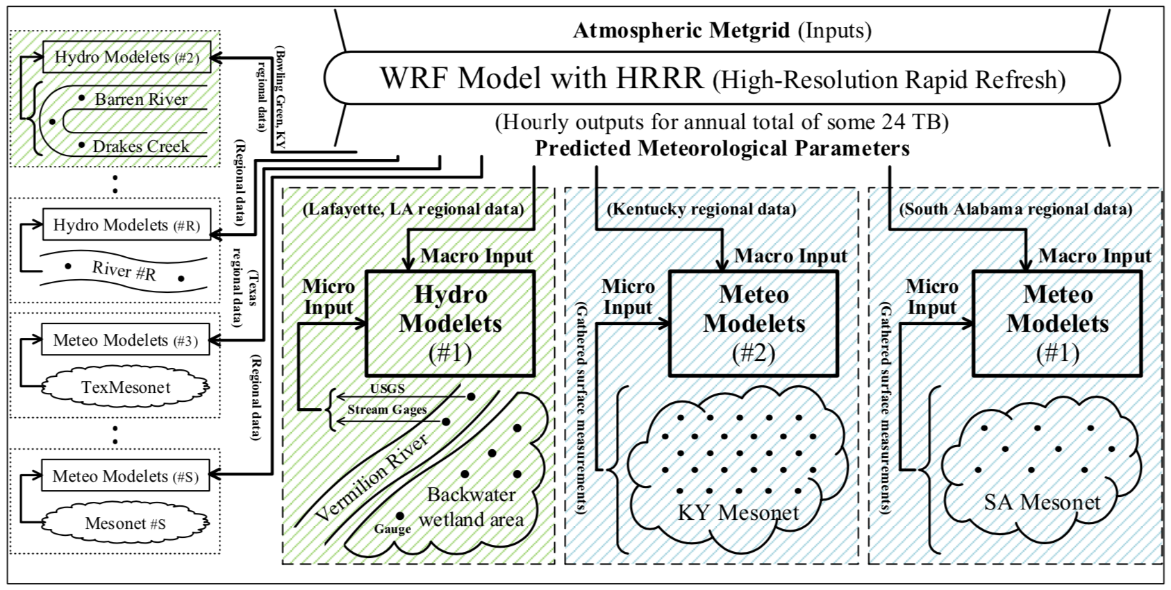
bigdata harness results from proper end-to-end simple neural network models (called NN modelets). NN modelets are trained inventively by huge datasets obtained continuously from (1) near-ground observations, via Mesonet stations or water
gauges, and (2) geo-gridded predictions based on computing physical atmospheric equations, via the Weather Research and Forecasting model with High-Resolution Rapid Refresh, known as WRF-HRRR. Various methodologies for accelerating bigdata
harness are under development and to be evaluated thoroughly during the project years.
PREFER aims to improve weather prediction spatially and temporally, with its NN modelet-based solutions applicable to all regions in the nation, for easy portability. It is being undertaken synergistically by jurisdictional collaboration across five universities in Louisiana, Alabama, and Kentucky, plus U.S. Geological Survey (USGS). Besides promoting the progress of science to advance the national prosperity and welfare by curbing potential disruption due to global warming, the project also includes comprehensive efforts for (1) building future leadership through collaboration and supervision of junior investigators for their career advances, (2) enriching educational materials on the focused disciplines and strengthening student research to boost workforce development, (3) aggressively recruiting and engaging underrepresented participants to support diversity, and (4) disseminating project outcomes and software tools widely.
Overview
PREFER solutions improve weather prediction spatially and temporally for wide applications to all regions in the nation, with easy portability to offer short-term and fine spatial resolution prediction. They aim to address the important problems of meteorological forecast applications (e.g., landfalling of severe thunderstorms or tropical systems), flood warning alert enhancement, backwater wetland storage capacity investigation for river flood mitigation, among others. To this end, the project utilizes simple NN (neural network) models for meteorological and hydrological parameter predictions, called Meteo Modelets and Hydro Modelets, respectively, as depicted in Figure 1 below. Modelet-based regional forecasting works effectively because huge amounts of meteorological and hydrological datasets required for model training are available continuously by means of (1) weather parameter gathering facilities in existence nationally (such as Mesonets and personal weather stations) and (2) USGS streamgages deployed on rivers and streams nationwide to obtain their hydrologic parameters in realtime. PREFER focuses on developing and establishing suitable Meteo and Hydro Modelets, and then on accelerating Modelet training as well.
Bigdata Harness Acceleration Methodologies
NN model training is known to be time-consuming and memory-hungry, and it usually employs a mini-batching technique to shorten the training time, with computed results of each layer in forward propagation held in DRAM to facilitate back propagation. Accelerating model training and inference is central to PREFER harness, because tens or even hundreds of NN modelets may be needed for a given region to predict various meteorological parameters together for accurate weather forecasting. This project deals with various bigdata harness methodologies, including (1) in-memory processing via computer system DRAM expansion, (2) execution resilience enhancement, and (3) high-compute density support by SC (stochastic computing)-based accelerators and by GPGPUs with desirable scheduling policies and execution support.
Applications of PREFER Weather Prediction Results
PREFER enables accurate prediction on severe thunderstorm activities, landfalling tropical systems, and local convection initiation process studies based on detailed information of local atmospheric profiles and stability. It involves research on (1) severe weather prediction with an aid of 2-D Meteo Modelets and (2) targeted forecasting to determine critical regions during storms for improving emergency management. Hydro Modelets under development aim at flood monitoring and river inundation forecasting in real time for regions of interest, with their inputs from the readings of both deployed streamgages and water gauges to be deployed. Their prediction results help to improve prediction accuracy on regional floods by the nearby river/stream. Additionally, developed water gauges in a backwater wetland area permit our investigation into (1) the wetland storage capacity for flood mitigation based on gauge reading results and (2) wetland ecological restoration after floods via gauge data for possible flow gate control between the wetland and its nearby water bodies.
University of Louisiana at Lafayette, 104 East University Avenue, Lafayette, LA 70503-2014. Ph. (337)482-6304